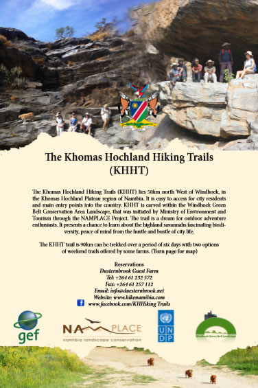
Khomas Hochland Hiking Trail description
⇒ Find us quickly at www.hikenamibia.com
Hikers' report
By Dr Werner Mödinger, Magdaleen Brits, Loumarie van Wyk and Albert Bossert.
May 2015.
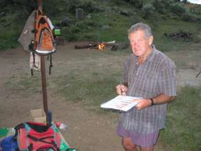
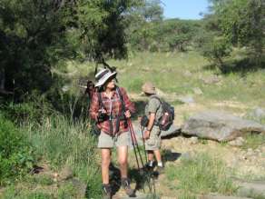
The above experienced hikers, together with John Mehliss, HOSA board member, and Albert Bossert, President of HOSA and designer and Project Manager of the Khomas Hochland Hiking Trail, walked the 6-day trail from 26 April to 1 May 2015. We were the first group of hikers on this newly developed trail, and our task was to test it, and make recommendations on improvements to the participating farm owners.
Introduction
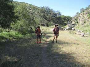
The hiking trail covers a distance of 91 km, over 6 days, through the most interesting and beautiful part of the Khomas Hochland. It crosses 5 farms - Düsternbrook, Otjiseva, Onduno, Godeis and Monte Christo. We are sure it will attract hikers interested in geology, bird-watching, trees, plants, animals, especially reptiles, archaeology and those who just love a hike through mostly unspoiled nature, in dry river beds over the rolling hills of the Khomas Hochland.
On our hike we were greatly supported by the owners of the farms, who, together with their helpers, walked with us and added new trail markers where necessary, cleaned the route, improved the safety and placed interesting and funny markers – of which some are mentioned in this report.
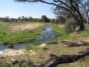
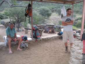
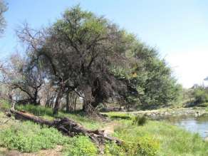
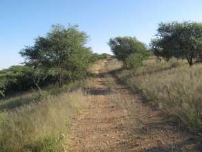
The route is now well-marked and should cause no problems to hiking groups. The overnight places are well designed, catering for all hikers needs - which includes hot showers (solar heated or using a “donkey”), clean toilets, braai facilities and a covered sleeping area. Lots of big trees provide ample resting spots along the route. Scenery is special. All kinds of game - oryx, kudu, warthogs, zebra, waterbuck, baboons, klipspringer, etc is in abundance. You might even see a leopard or two. Bird life along the Aretaragas and Otjiseva rivers and at dams are almost unbelievable plentiful - from eagles to water birds and lots of others. Fences are crossed with ingenious steps using old car tyres.
The option of slack-packing was discussed and might be implemented as well as the possibility of providing fresh bread and meat. This would make the trail accessible to those who are not able to carry a heavy backpack all the way.
Day 1 (15 km)
The trail starts at the Guest Farm Düsternbrook, follows the Otjiseva River on the Otjiseva Farm, passing UNDER THE BIG TREES, RIVER/GAME WATCH WALK and GEMSBOKKOELTE before turning into the mountains. The vegetation is of the Bosveld type and the often large trees provide lots of shady places to rest, for instance under the BIG FIG TREE REST, where we had lunch – near 12km. The owner of the farm showed us rock engravings at KLIPMERK GATE. The meaning of these engravings is still unknown. We rested a lot on rocks in the river bed. The path leads along some narrow kloofs with some interesting rocky waterfalls – one too high to climb and a path was made up a hill and around it. From the top of the mountain - at the TOKTOKKIE TRACK REST- we had impressive views of the surrounding hills and flatter countryside looking towards Windhoek. A last an easy climb leads to the beautiful setting of the overnight stop GUSTAV POSTEN, still on the farm Otjiseva, next to a big dry dam. It is completely in the wilderness and the sounds of Africa’s wild animals are heard and game seen, without having to be quietly. Some interesting signs boards are SEXY FIG TREE, THE-ROCK-UNDER-THE-ROCK, SIT-GAT-RUS-BENE.
Day 2 (8 km)
We follow again a riverbed on the KLIPPEKOU KLIM uphill until we reach the border with the farm Onduno before the SLAGYSTERKLIP gorge. We sit a while on the rocks at the RED ROCK LIZARD REST waterfall and spend some time at the PARTRIDGE POOL and watch lots of birds coming to drink water. At a farm dam, with water for a large number of cattle, we are met by the owner of this farm. He explains to us the route downhill into another riverbed with Oryx, Kudu, wonderful flowers and trees, past the CREEPY CORNER. We have lunch at the side of a farm road under some shady bushes at the top of a hill where there is a nice breeze - this is experienced at higher spots on the trail. Then up a hill to YIPPIE ON TOP ...!! Early in the afternoon we arrive at the next overnight place - also next to a dam - where we have enough time to explore the surroundings and observe the bird and animal life. The camp is below the LOOK UP!! BABOON MOUNTAIN, on the bank of a small dry river in between two rocky hills with steep kranses. The one hill is called Bobbejaan kop - obviously a baboon sleeping place.
Day 3 (21 km)
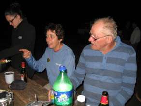
On this day we cover the longest distance of 21km. It start by going up and down on hills and grassland areas, with small bush and beautiful vistas, where we see lots of gemsbok, kudu and zebra, passing KOELTE BOOM and DEATH IN THE RIVER. After crossing the corner border to Godies, at 6km and climbing the SCORPION HILL we reach ZEBRABAD and cross over into two valleys with a beautiful long valley down BIRD NEST GORGE, where leopard tracks leads us down to the lunch spot in the Middagrivier at 10km. A 4 m long python lying in the sun in a rocky area before the DEATH VALLEY gives us exiting moments. We follow this long bigger dry river, for about 3km, with very high cliffs past BIG HANGING CLIFFS and the MENSVRETERGROT to the COMPRESSOR REST. In the ROOIKAT KLOOF a steep climb and crossing at 16km takes us to another valley past the TWIN ALOE AT A WATER SLIDE and LAST WATER. Just before we reach our next overnight place we have to climb up and down rocks in the narrow impressive LOVEBIRD GORGE. We saw and heard the Rosy-faced Lovebird that breeds here, but we also had a close encounter with a 3 meter long Black Mamba. Just before sunset we meet with Ursel, the owner of Godeis, with beers for our sun downer drink, on the Sun downer hill above the overnight camp, to watch a beautiful sunset scene as the sun go down behind the many mountains of the Khomas Hochland.
Day 4 (16 km)
We leave our overnight place again through the LOVEBIRD GORGE, past GATKRAP BOOM and turn right into the Otjompaue river, which forms a wide valley. Passing the PIEPIE VALLE and the GROOT KAMEELDORINGBOOM EN SY KLIP BALLE, which brings us to the Onduno Farm border and the VEGTENDE BULLE PUT. The BABOON BAR gorge is something special. We see many, unfortunately dry dams and a number of San places one at BUSHMAN/SAN PLACE. After the ZEBA PEEK HILL, GOGGA OPDRAANDE you can have lunch at BLOW WIND BLOW - GIGGLE REST. We passed KAALGAT RANTE and STONE SIT to a point, where we rested for the last time and looked at the Onduno homestead at ANKE’S HOUSE VIEW. Then down to the big dam with lots of water and the CROAK DRINKING PLACE. Suddenly we were back at our Day 2 overnight camp. We had excellent weather on our whole trip, sometimes even a bit too warm, but during this night the thermometer fell to about 5°C.
Day 5 (15 km)
Each day brings interesting vistas and so did this day not disappoint! We had a pleasant hike past LEKKER SWIMMING, THROUGH THE BEAUTIFUL BUSHES up on GRANDPA’S PATH, past KIEKIE DAM to the WINDHOEK REST. Windhoek city can clearly be seen in the distance. We TAKE IT SLOW BUT GO on THODO’S PATH through GAT SKEUR DEUR DRAAD to the highest point at 360⁰ AND OH SO FAR FAR AWAY!! with the best views all round of the whole trail, seeing as far as Okahandja and Windhoek while resting a round hill just under 2000 m above sea level.
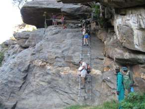
After we have done some ups and downs past HEAVEN REST, BERND’S MOUNTAIN REST and ENORMOUS COCOON CORNER, we crossed the border to Monte Christo Farm on LEVEL ON THE GRAVEL to the WATERFALL. We climbed down this breathtaking high waterfall with 5 well secured wooden ladders. We pass KORT-PAD-LANG-PAD, with a well deserved rest at SEER-KNIE-DAMRUS and walking past the STEENBOKKIE PLEK we finally reach the Aretaragas River at TARENTAALDRIF. Breathtaking hiking for a kilometre along this river, watching hundreds of water birds and plenty of game pass SO CLOSE, we come to the Tree House, our overnight place on this farm. This tree house is a 3-storey building, built around and in a massive big Ana tree, with double decked 5 star toilets, a lookout and braai area on the first floor, overlooking a dam constructed round the tree. This was very special.
We took a walk to the Monte Christo home. It has a number of small lakes, which is ideal for bird watching such as water birds and Fish eagles. In total on this hike we identified more than 50 species of birds. We saw many oryx, waterbuck, springbok, zebra, kudu, warthogs and other small mammals.
Day 6 (14 km)
The last day of the KHHT is a pleasant walk along the Otjiseva River with a number of river crossings and passing the following markers DRIE-ANA-BOME-RUS, COOL TREE REST, VLAKVARKGATE, WATERVOëLS LOOP and WATER KLIPPE. This day led us from Monte Christo via Otjiseva back to the starting point at Düsternbrook.
General Remarks
The Khomas Hochland Hiking Trail is an excellently planned trail, and goes through widely varied landscapes. The distances require a certain amount of fitness, but the possibility of slack packing and being able to buy meat, bread and drinks from the farmers every day, should make it possible for more hikers. We are sure it will attract a very large number of hikers from all over Southern Africa and even tourists from overseas. We expect that in due course it will become the most hiked trail in Namibia after the Fish River Canyon.
Some walking is on farm roads and makes a difference at some places.
It was wonderful to see the enthusiasm, with which the farm owners accepted and supported the idea of this hiking trail. We wish everybody involved a great success with this tourism venture in Namibia.
Thanks
We want to thank everybody involved and especially the Hiking Organisation of Southern Africa (HOSA), who made our trip to Namibia possible. A special word of thanks goes to the owners of the farms, from whom we got real VIP treatment. They went out of their way to give us their fullest assistance and support when we made some suggestions for improvement or change to the trail. We also thank NamPlace, especially Aaron, for the transport arrangements from and back to the air port as well as the promise of financial support to our travel costs. We thank Albert Bossert for the wonderful idea and planning of this hiking trail and for his patience and leadership along the full trail. Finally, we thank all members of our hiking group and all those who walked with us on parts of the trail, for their willingness to share their time and wide knowledge of this wonderful part of Namibia. It made this hike a very special experience.
» Download a flyer about the Khomas Hochland Hiking Trail here.
» Find out how to make a reservation.