Geology
 Much of the landscape comprises the Namib Sand Sea with the eastern margins comprising metamorphic mountainous landscapes and the limestones and shales of the Naukluft mountains.
The Naukluft mountains formed some 850 million years ago during the formation of the continent of Gondwana when the converging of land masses produced mountain belts formed from shallow water marine deposits. One giant piece of limestone moved westwards for about 120 km to become the Naukluft mountains of today.
 The Namib Sand Sea is actually a system of two dune seas, one on top of another. The older one is around 21 million years while the younger one covers the older system and has been active for about 5 million years. These dune sands have their origins in the Orange/Vaal River Basin in central to eastern South Africa. In short sediments were transported by the Orange River to the coast where longshore drift, fuelled by powerful winds, transported the sediments northwards along the coast where they were lifted by these winds and deposited inland to form the central Namib Sand Sea.
The bedrock under the two sand seas forms a gradually rising peneplain studded by occasional inselbergs. Westerly flowing rivers feed fresh rainwater into the old palaeovalleys and the older semiconsolidated sand sea. The water which reaches the coast emerges as small springs at hidden, isolated locations and is many thousands of years old when it appears again at the surface.
During the Palaeogene, between 65 and 23 million years ago, Africa separated from the neighbouring parts of Gondwanaland and emerged as a continent of its own. As a result of these plate tectonic movements, the southern African subcontinent underwent various stages of uplift, and the present interior was subject to erosion. Deep erosion from the end of the Cretaceous onwards, 65 million years ago, caused the Great Western Escarpment to migrate eastwards, leaving behind the low lying peneplain occupied by the Namib Sand Sea today.
Outcrops occur sporadically along the coast in a few inselbergs within the dunes and along the eastern border of the dune belt. The largest coastal outcrop area is the one between Conception Bay and Meob Bay. Inselbergs of Namaqua and Sinclair Formation rocks, such as the Uri Hauchab, Hauchab and Awasib Mountains protrude in the southern half of the Namib Sand Sea dune field and along its eastern edge but are conspicuously absent in the northern half.
The Orange River system has been in existence since the early Cretaceous transporting sediment westwards. High sea levels, up to 170 m above the present sea level during the Eocene, in combination with longshore drift deposited marine sediments on the Namib bedrock up to 30 km inland of the present coastline. Similarly, sea level falls of as much as 120 m or more during the Oligocene exposed huge areas of the offshore Orange River delta and the continental shelf to its north. Thus, large areas of the Cretaceous and Cenozoic marine sediments in the delta and on the continental shelf were exposed to the strong southerly winds for long periods of time and were huge sources of sand for the two central Namib Sand Seas.
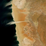
The main wind directions are southerly along the coast and southwesterly further inland. The overall movement of sand is consequently toward the north or northeast. The greatest rate of movement is along the coast where southerly wind blows rather strongly most afternoons and evenings. Barchan and longitudinal dunes prevail in this region. Changes in wind direction change the facing direction of the dune crests. On the eastern edge of the Namib Sand Sea near Sossusvlei, the wind direction is more variable from day to day. Consequently, this is the region where stellate and pyramid dunes are developed.
 Only two rivers, the Tsondab and Tsauchab, flow within the Namib Sand Sea. The present Tsondab and Tsauchab rivers have cut new channels into their old palaeovalleys and their end points are the Tsondab and Sossus Vleis, respectively. The two rivers, the Tsondab and Tsauchab, have relatively small catchments in the escarpment region where rainfall is low. Floods in the Tsondab and Tsauchab Rivers only reach their respective end points occasionally.


